For AZ, CA, CO, EASTERN STATES, ID, MT, NM, NV, OR, UT, AND WY
1) To get the Township and Range go to http://www.geocommunicator.gov/blmMap/Map.jsp?MAP=SiteMapper
2) Zoom into your location and use the identify button at the top, then click the location you want.
3) Then select the PLSS button at the top and it will give you the Mining Claim Authorizations Cases
4) After getting the Township and Range information go to http://www.blm.gov/landandresourcesreports/rptapp/criteria_select.cfm?rptId=19&APPCD=2&
5) Then check the Meridian Township Range box then click the Select Criteria button
6) Then click the Set Admin State and select the state and click the Set Case Disposition button
7) Then select the case status you wish (I highlight them all) the click the Set Meridian Township Range button
8) Then using the Meridian, Township, and Range fill in the blanks and select the Add to MTR list and then Select the Run Report Button
Using the Meridian of 21, Township 13N, Range 9E this is the report run.
UNITED STATES DEPARTMENT OF THE INTERIOR
BUREAU OF LAND MANAGEMENT
MINING CLAIM GEOGRAPHIC REPORT
LIST OF MINING CLAIMS BY SECTION
MER TWP RNG SEC
21 0130N 0090E 001
Serial Num Quad Claim Name/Number Claimant(s)
CAMC130660 SOREFINGER ANNEX NAYLOR RAYMOND A
Lead File Case Type Status Loc Dt Last Assessment
CAMC258399 384401 Closed 08/31/1992 0000
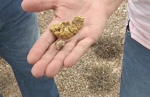
 The simplest way to prospect for gold!! Alot of recreational prospectors just simply “pan”, if you think about it, you grab a gold pan and find a river or small body of water and you have the ability… if in a known gold bearing region, to actually come up with some color in your pan!! Thats when it all goes down hill from there. First you find a little color.. then a few pickers, next thing you know your looking to buy a sluice and then a highbanker and when that doesn’t cut it anymore your packin in a 6″ dredge!!! So basically the meager gold pan was your gateway drug into the world of gold fever!! 98% of all gold prospectors never recover!!